By Sarah Grunau
A newly proposed Harris County flood zone map adds heightened flood risks for households across the Houston area.
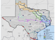
A draft of the Federal Emergency Management Agency’s new and long-awaited flood risk map will likely go through several variations before final approval. The map — which was quietly released on the agency’s website two weeks ago and intended for technical reviews by floodplain administrators — marks a major revision in Harris County’s flood risk zones that haven’t seen a comprehensive update in nearly 20 years.
Under the proposed map — which will influence insurance coverages as well as local development rules — the 100-year and 500-year floodplains widely expanded in south Houston, while some areas in southwest Houston saw a reduced flood risk. Both floodplains appeared to spread in northeast Harris County near Lake Houston under the proposal.
Jim Blackburn, an environmental law professor at Rice University, said that a reevaluation of rainfall rates is one of the most significant developments since the county’s previous flood maps were released in 2007. The federal agency’s newly proposed map reflects about a 30% increase in rainfall rates.